Trail
Free
C&O Canal Towpath
184 miles of level crushed stone on the Maryland bank, reached by a footbridge and an awkward spiral staircase.
1–5 hoursFree. The towpath itself carries no entrance fee720 ft away
A booking made through these earns us a commission from Viator. The price is the same, and the commission had no bearing on what is recommended.
Trail
Last updated
The cliff ledge that produces the photograph everyone has seen of this town, and about a thousand feet of climbing to reach it.
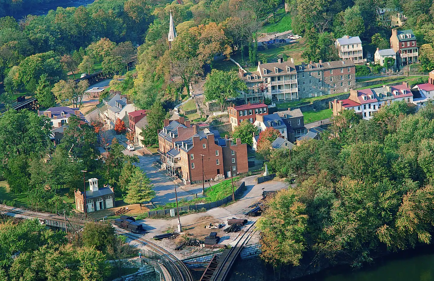
Photo: National Park Service Digital Image ArchivesPublic domain
The Goodloe Byron Memorial Footbridge, the usual walking approach from the lower town, closed on 27 July 2026 for stairway construction. The park reports the trail itself remains accessible and recommends alternative routes. Check nps.gov/hafe for current conditions before you travel.
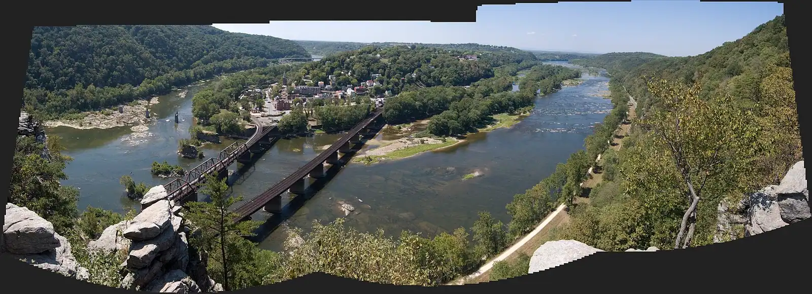
Every image you have seen of Harpers Ferry from above — the wedge of town between two rivers, the bridges, the ridges folding away behind — was taken from a bare rock ledge on the Maryland side of the Potomac, and the only way to it is on foot, uphill.
The numbers first, because this is where visitors underestimate the place. Depending on which combination of trails you walk, Maryland Heights is 4.5 to 6.5 miles round trip with 990 to 1,788 feet of elevation gain, and the park rates it moderately strenuous to strenuous. Three to four hours is realistic for a reasonably fit adult who stops at the top. There is no water on the trail, no restroom on the trail, no shelter, and no shortcut down. It is not a stroll with a view at the end. It is a proper climb in a humid river gorge, and in July the bowl holds heat in a way that catches out people who have hiked further in cooler places.
The first stretch is a set of switchbacks up through mixed hardwood, and it is relentless rather than technical: no scrambling, no exposure, just gradient. Higher up the grade eases along the ridge, and a signed spur — the Overlook Cliff Trail — drops out to the ledge itself. That ledge is the reward. It sits on the cliff face rather than the summit, which is why the view is down onto the town rather than across at it.
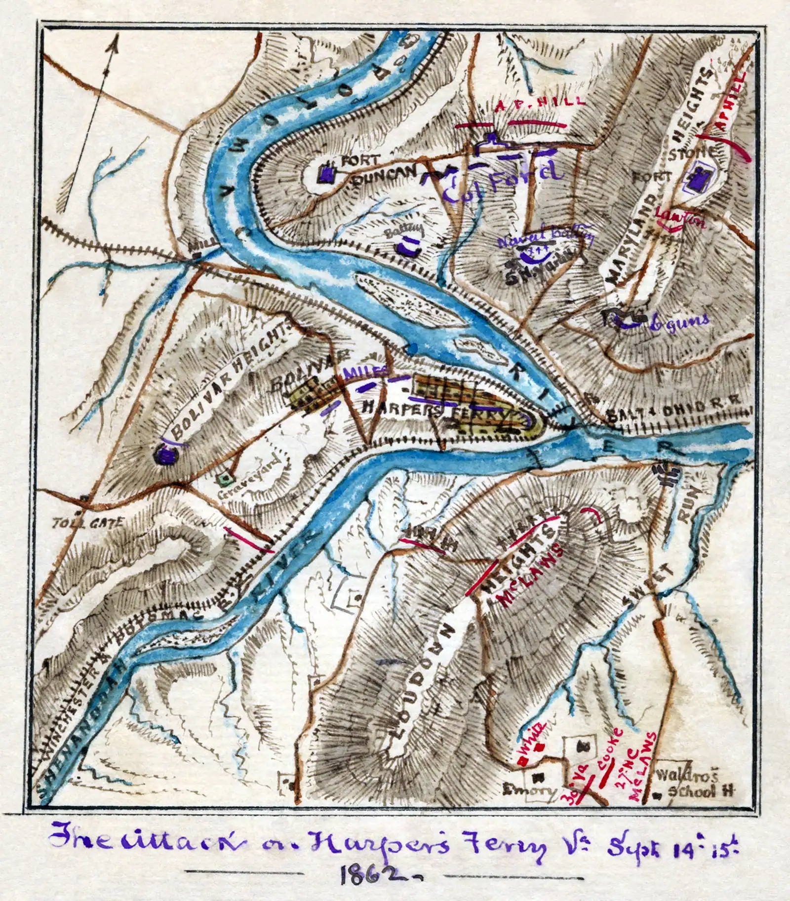
Carry on past the spur and you get the other half of the mountain: the Civil War ground. Confederate and Union forces both understood that whoever held this cliff held Harpers Ferry, and the ruins are still up there — a stone fort on the summit ridge, gun emplacements cut into the hillside, and the platform built for a 100-pounder Parrott rifle that soldiers hauled up this slope by hand. In September 1862 artillery on these heights was one of the three batteries that forced a Union garrison of around 12,500 men to surrender.
Take twice as much water as you think you need. That is the sentence that matters most on this page.
Under normal conditions: walk east out of the lower town, cross the Potomac on the footbridge attached to the railroad bridge, take the spiral staircase down to the C&O Canal towpath, turn upstream and walk a few hundred yards to the signed trailhead on your left.
That footbridge has been closed since 27 July 2026 for stairway construction, so the walking approach from the lower town is not currently available in its usual form. The park states the trail itself is still accessible and points visitors toward alternative routes on the Maryland side. Read the park's current conditions page before you leave home — during construction this is the one piece of information on the whole site that can change between now and your visit.
However you reach the trailhead, park on the Maryland bank rather than attempting to find space in the lower town, start early, and be aware the trail is open in daylight hours only.
The normal approach walks out of the lower town, crosses the Potomac on the Goodloe Byron Memorial Footbridge cantilevered off the railroad bridge, descends a spiral staircase to the C&O Canal towpath and turns upstream for a few hundred yards to the trailhead.
That footbridge closed on 27 July 2026 for construction work to improve its stairway. The park's own current conditions page states that the Maryland Heights Trail itself remains accessible and advises considering alternative routes to it.
We are not going to invent a detour for you. Which approach the park is recommending, where it is telling people to park on the Maryland bank, and how much roadside space exists there are exactly the details that shift during a construction project, and a wrong answer here costs you a morning. Check nps.gov/hafe for current conditions in the week you travel, and if you are driving a long way for this specific hike, check again the night before.
Two things that are true regardless of the detour. The trail is daylight hours only, and rangers do enforce that. And parking on the Maryland side has always been limited and informal compared with the visitor centre lot, so early arrival matters more than usual.
From the towpath the trail turns uphill immediately and stays uphill. The switchbacks through the lower woods are the hardest section, and they do the bulk of the elevation in the first mile or so. Footing is rooty, rocky and uneven, with loose stone on the steeper pitches.
Nothing about it is technical. There is no scrambling, no exposure on the main trail and no route-finding problem — the junctions are signed. What it is, is sustained. People who walk regularly on the flat are often surprised by how little that helps.
The mountain has its own microclimate. Under canopy on a humid August morning the air does not move, and the heat index in the gorge can be well above what the regional forecast promised. Cases of people running out of water on this trail are common enough that the park flags it.
Two honest recommendations. Start on the first shuttle or earlier, and treat ten in the morning as your turnaround deadline in high summer. And bring more water than feels sensible — two litres a person is not excessive on a hot day, and there is nowhere to refill between the towpath and the top.
Coming down is where knees and ankles complain. Poles help considerably on the descent, far more than on the way up.
The overlook route. Up the switchbacks, along the ridge, out on the signed Overlook Cliff spur, and back the same way. This is the shorter end of the range — around four and a half miles round trip and something close to a thousand feet of climbing — and it delivers the photograph. For most day visitors this is the correct choice.
The combined route. Continue past the overlook spur to the summit ridge and the Civil War remains: the stone fort, the gun emplacements, the Naval Battery ground and the 100-pounder platform. This pushes you toward the six-and-a-half-mile, 1,788-foot end and adds an hour or more. Worth it if the military history is why you came; not worth it if you want a view and lunch.
What the overlook is and is not. The ledge is a bare rock shelf on the cliff, not a built platform, and it is unfenced. It is genuinely exposed, it slopes, and on an October Saturday there is a queue for the photograph. Keep children within arm's reach and stay off wet rock.
What you cannot do. There is no loop that returns you to a different point, no vehicle access to the top, and no water source anywhere on the mountain.
Stand on the overlook and the strategic problem solves itself. Harpers Ferry sits at about 509 feet. Maryland Heights tops out near 1,448. Anything on this cliff commands the town, the bridges, the armoury ground and both river crossings, and nothing in the town can reach back.
Both armies knew it. The fortifications you walk past are substantial: a stone fort on the summit ridge, cut emplacements on the slope, and a platform built for a 100-pounder Parrott rifle, a gun weighing several tons that was dragged up this mountain by soldiers and mules over ground you have just climbed with a daypack.
In September 1862 Stonewall Jackson split his force three ways and put artillery on Maryland Heights, Loudoun Heights and Bolivar Heights simultaneously. The Union garrison in the bowl below had nowhere to go. Roughly 12,500 men surrendered — commonly cited as the largest surrender of United States troops until Bataan in 1942. Antietam was fought two days later, thirteen miles north.
The Union rebuilt the works afterwards and held the heights for most of the rest of the war. That is why there is so much stone up here: it was fortified, lost, retaken and fortified again.
Straight-line distances, so allow more on the road — the island is long and has one main parkway.
Trail
184 miles of level crushed stone on the Maryland bank, reached by a footbridge and an awkward spiral staircase.
1–5 hoursFree. The towpath itself carries no entrance fee720 ft away
Landmark
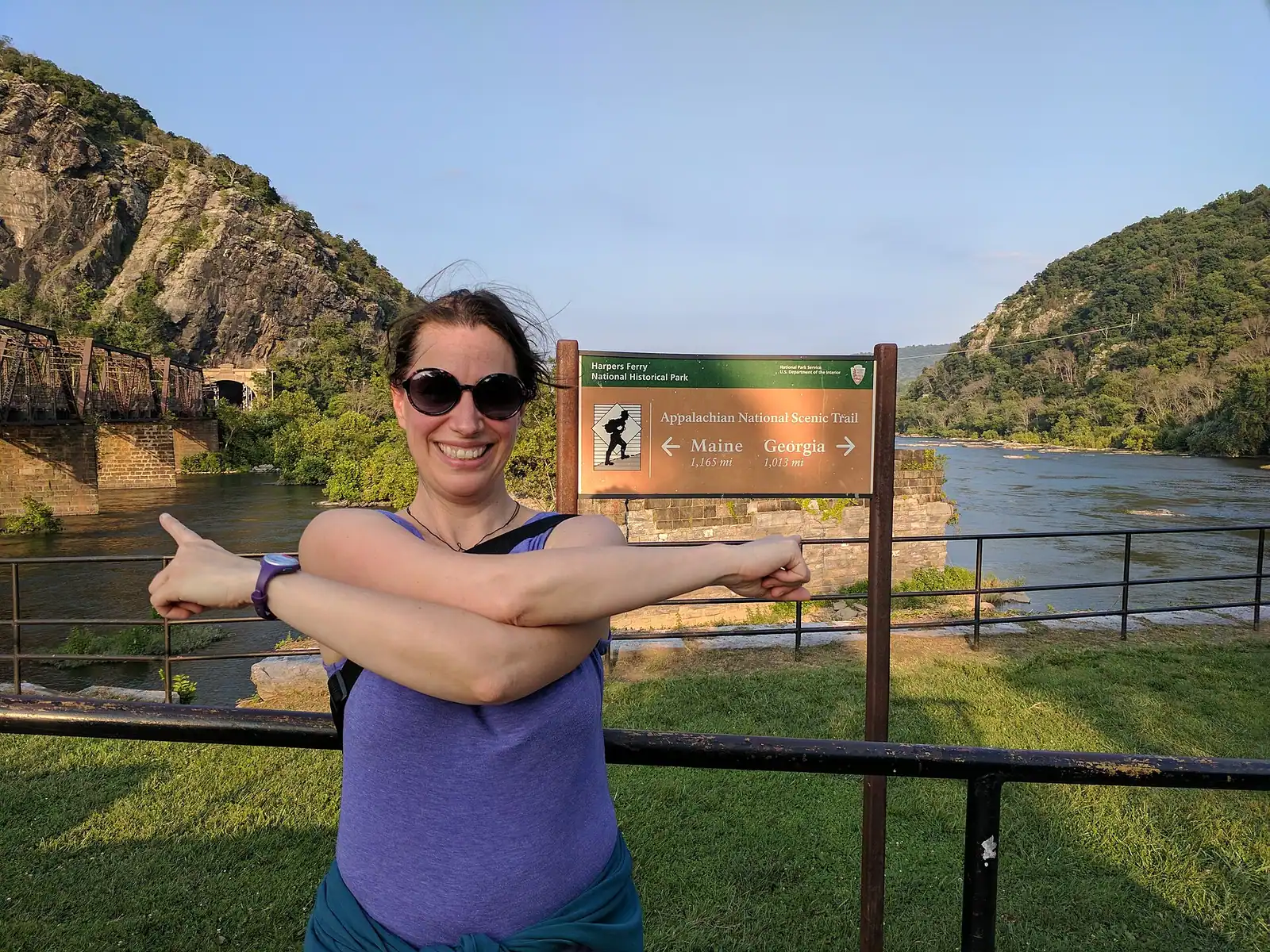
The walkway bolted to a working railroad bridge that carries the Appalachian Trail over the Potomac — closed since July 2026.
10–25 minutesFree to cross when open; the park entrance fee applies to your vehicle0.3 mi away
Viewpoint
Ninety seconds from the shuttle stop, level the whole way, and the only spot where the town's geography explains itself.
10–30 minutesFree; covered by the park entrance fee already charged on your vehicle0.4 mi away
Neighbourhood
Two streets and a flight of stone steps, all of it inside a national park, with the high-water marks still on the walls.
2–5 hoursPark entrance fee applies; National Park Service exhibit buildings are then free to enter0.3 mi away
Where this place fits into a day, and the pages that plan one.
Things to do
The United States built its second national armoury on this ground in 1799 because the ground did the work. Two rivers arrive at the same corner…

Guide hub
At most national parks the town is outside the gate. Here the town is the park. Harpers Ferry National Historical Park covers roughly 3,660 acres in…
Things to do
The hiking here is entirely a consequence of the geology, and ten minutes understanding that will save you picking the wrong trail. Two rivers cut…
Things to do
Start with the correction, because it saves an afternoon. The photograph you have seen of Harpers Ferry — the whole town laid out on its spit of…
By season
Harpers Ferry in October is the version of this place that ends up on other people's walls, and it is worth understanding both why it works and what…
Guide
The colour reaches the ridge tops before it reaches the streets, the crowd arrives at eleven, and on the first weekend of November the last bus back moves ninety minutes earlier overnight.
9 min readEmmett Coyle
Guide
The town sits in a bowl with high ground on three sides. You are either on a level towpath or climbing a thousand feet, and there is very little in between. Choose accordingly.
9 min readEmmett Coyle
Guide
The overlook everyone photographs is a thousand feet above the town, with no water on the way up and a descent that is harder than the ascent. Know the numbers before you start.
9 min readEmmett Coyle
Hard enough that the park rates it moderately strenuous to strenuous. Depending on route it is 4.5 to 6.5 miles round trip with 990 to 1,788 feet of elevation gain, and three to four hours is a realistic figure for a fit adult. Nothing is technical — no scrambling and no exposure on the main trail — but the gradient is sustained and the footing is rocky and rooty. There is no water and no restroom on the mountain, and the river gorge holds heat in summer.
The trail itself was listed as accessible in late September 2026, but the usual walking approach was not: the Goodloe Byron Memorial Footbridge over the Potomac closed on 27 July 2026 for construction work on its stairway, and the park has been advising visitors to consider alternative routes. Because detour arrangements shift during construction, check the park's current conditions page at nps.gov/hafe in the week you travel rather than relying on anything written here.
From the Overlook Cliff on Maryland Heights, a bare rock ledge on the cliff face across the Potomac in Maryland, reached by a signed spur off the main trail. It sits below the summit rather than on it, which is why the view looks down onto the town, the confluence and the bridges rather than across at them. The ledge is unfenced and sloping, so keep well back from the edge and stay off it when the rock is wet.
Three to four hours for the overlook and back at a normal walking pace with a stop at the top. Adding the summit ridge and the Civil War fortifications — the stone fort, the gun emplacements and the 100-pounder Parrott platform — pushes it toward five hours and toward the longer, steeper end of the distance range. Add the shuttle at each end when you are planning against the last bus back to Cavalier Heights.
Older children who already walk hills happily, yes. Younger ones, no — this is a sustained thousand-foot climb with no water, no restroom and no way to cut it short, and the reward at the top is an unfenced rock ledge above a long drop. For families the honest alternative is Bolivar Heights, which is flat, short and open, or The Point in the lower town, which gives you the confluence and three states on level paving.